Altitude & Azimuth: The Horizontal Coordinate System
The horizontal coordinate system, also known as the Alt/Az system, is a method for describing the exact position of objects in the sky, such as planets, the Sun, or the Moon.
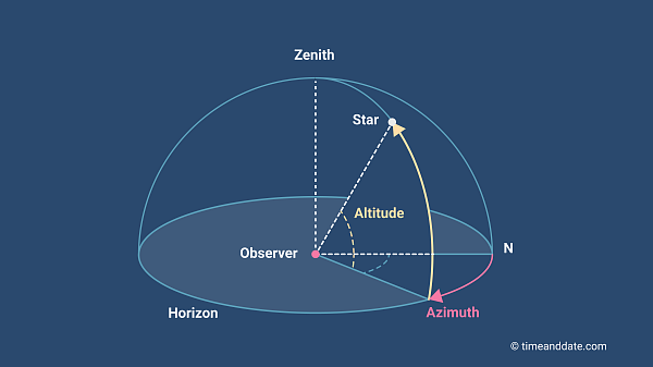
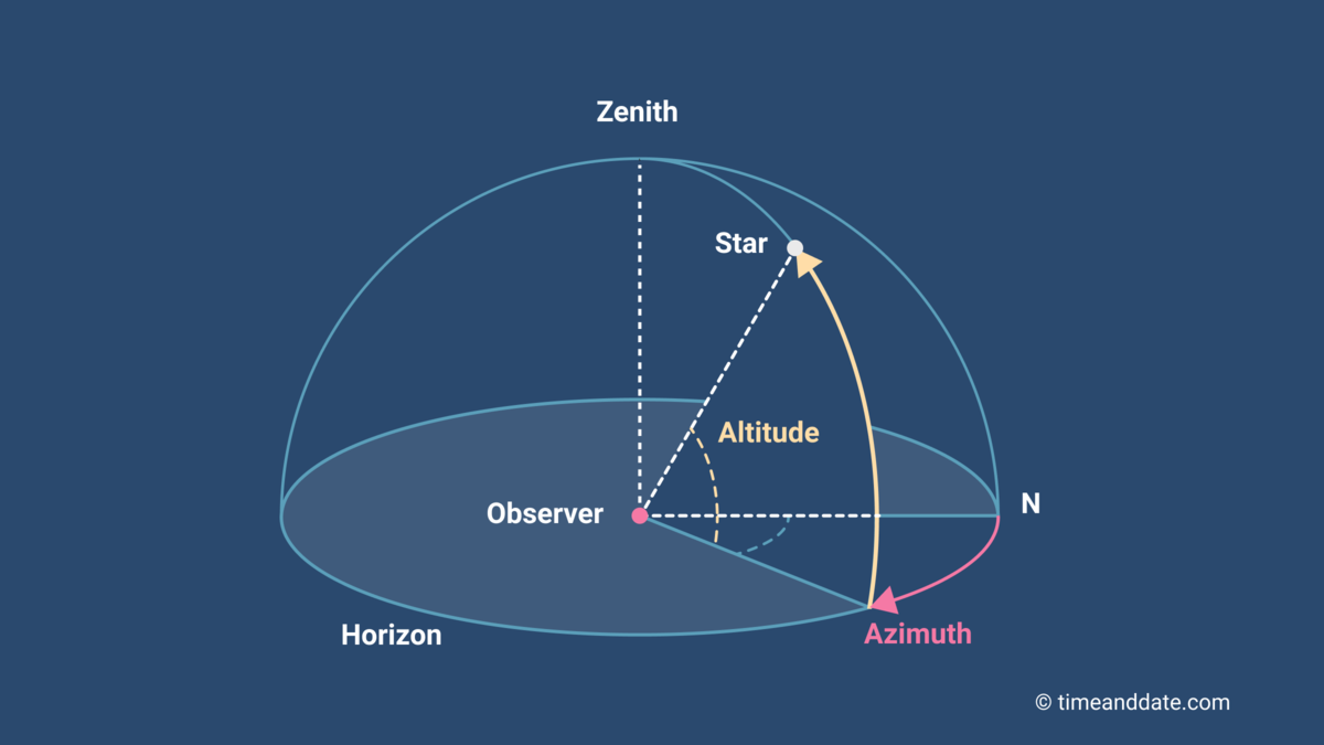
Illustration 1: The upper hemisphere of the celestial sphere.
©timeanddate.com
This system is also used by timeanddate.com to describe the positions of the Sun, the Moon, and the planets of our solar system.
Distance Irrelevant
Based on two coordinates, altitude and azimuth, the horizontal coordinate system provides the general direction in which to find a celestial object. Although the distance of the visible planets, stars, and galaxies differs by billions of light years, the system ignores the depth of space as an object's distance is irrelevant for the purpose of locating it in the sky.
The Celestial Sphere
Imagine the sky as a dome towering above you, its edges resting on the horizon. This is the backdrop the horizontal coordinate system uses to map the sky and describe the positions of its objects. To compare, the geographic coordinate system uses the Earth's surface as a backdrop to determine a position.
In effect, the system also includes the invisible half of the sky that is below the horizon. The dome above you is called the upper hemisphere and the invisible part of the sky below you is the lower hemisphere. Together, they form the celestial sphere, an imaginary globe surrounding you, with you at its center.
Astronomical terms & definitions
The Celestial Horizon
The horizontal line separating the two hemispheres is called the celestial horizon. It is a continuation into space of the imaginary plane created between you and the horizon around you. If the Earth were flat, the celestial horizon would follow the terrestrial plane. However, since we are living on a globe, it is defined as the imaginary plane perpendicular to the direction of gravity at the observer's location.

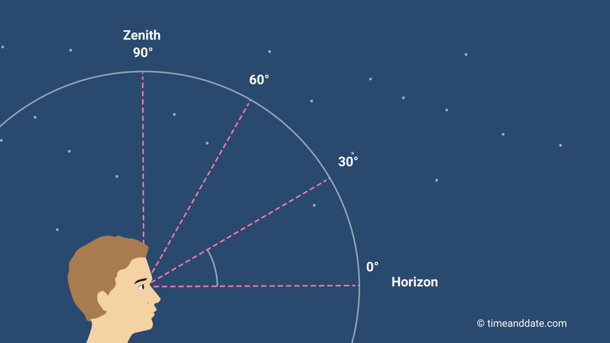
Illustration 2: The altitude is the angle an object makes with the horizon.
©timeanddate.com
Altitude and Azimuth
Just as the geographic coordinate system uses latitude and longitude to define any location on Earth, the horizontal coordinate system provides altitude and azimuth angles to locate objects in the sky.
- Altitude or elevation: The angle the object makes with the horizon. Objects that seem to touch the horizon have an altitude of 0°, while those straight above you are at 90° (see illustration 2). Anything below the horizon has a negative angle, with -90° describing a location straight down. In this and other celestial coordinate systems, the location straight above you is called zenith while the point exactly below you is referred to as nadir.
- Azimuth: The object's cardinal direction, such as north, east, south, or west. It is specified as the horizontal angle the object makes with a reference direction, such as true north (see illustration 3). Imagine a vertical line connecting the object with the horizon. The azimuth is the angle between the spot where that line crosses the horizon and the reference direction. If true north is used as reference, it is represented by an azimuth of 0°, and angle values increase towards the east. This means, for example, that an azimuth of 180° means due south.
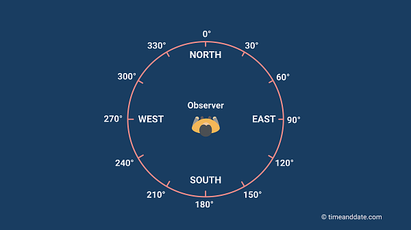

Illustration 3: The azimuth refers to the object's cardinal direction.
©timeanddate.com
Example: If Venus is at an altitude of 45°, with an azimuth of 270°, as seen from your location, this means that you will find the planet in a western direction at an elevation exactly half way between the horizon and the zenith.
Note: Since true north is the reference direction most commonly used, all azimuths displayed on timeanddate.com refer to true north. However, some astronomical conventions still follow the traditional method of using true south as a starting point for azimuth angles.
Depends on Location and Time
The horizontal coordinate system owes its name to the fact that it is based upon the observer's horizon. As the horizon's limits – and, therefore, the portion of the sky you see – depends on your location, an object's altitude and azimuth angles shift as you move to a different spot on the Earth's surface. What's more, most celestial objects move across the sky, so their coordinates change as time goes by, even if you stay put.
This means that the angles provided by the horizontal coordinate system apply only to a specific location at a specific time.
Doesn't Work at the Poles
While the horizontal coordinate system provides an easy way to define a location in the sky at almost any location on Earth, it is not possible to define an azimuth at the North Pole or the South Pole, rendering the system useless there.
At the North Pole, for example, it is easy to find the Polaris, the North Star. It is very close to the zenith position, so you have to look straight up to see it. However, you will not be able to describe the location of any other star using an azimuth angle because all of them are south of Polaris.