What Are Longitudes and Latitudes?
Cartographers and geographers trace horizontal and vertical lines called latitudes and longitudes across Earth's surface to locate points on the globe.
Longitudes and latitudes form Earth's geographical coordinates.
© timeanddate.com
Together, they form the Earth’s geographical coordinates, and represent the angular distance of any location from the center of the Earth. Both latitudes and longitudes are measured in degrees (°) and minutes (′).
Astronomical terms & definitions
Dividing Earth Into Hemispheres
The Earth is, almost, but not quite, a sphere that rotates around its axis. Scientists call this shape a spheroid or ellipsoid. If we draw a line passing through the center of the Earth along its rotational axis, the line would pass through the North and the South Pole.
The equator is an imaginary line perpendicular to this axis. It is equidistant from the North and South Poles, and divides the globe into the Northern Hemisphere and Southern Hemisphere.
Most locations on the equator experience consistently high temperatures throughout the year. They also experience at least 12 hours of daylight every day during the year. On the equinoxes—September and March—the Sun is directly overhead the equator, resulting in almost exactly 12 hour days and 12 hour nights.
Is the Moon upside-down in the other hemisphere?
Imaginary Circles
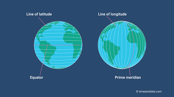
Often called parallels or circles of latitude, latitudes are imaginary circles parallel to the equator. On a map where north is up, latitudes run laterally (left to right). They are named after the angle created by a line connecting the latitude and the center of the Earth, and the line connecting the equator and the center of the Earth.
Latitudes specify the north-south position of a location on the globe. Locations in the Northern Hemisphere are identified by northern latitudes and are assigned a suffix of N for north. Southern Hemisphere locations, on the other hand, are on southern latitudes and are assigned a suffix of S for south.
Find celestial objects in the sky

The major latitudes and longitudes.
© timeanddate.com
Notable Latitudes
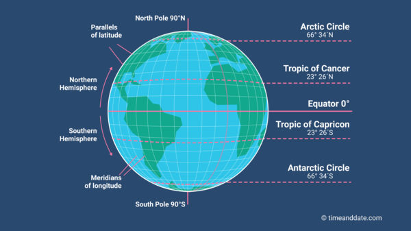
The equator represents 0° latitude, while the North and South Poles represent 90° North and 90° South latitudes. In addition to the equator, there are four other major latitudes that are usually found on maps and globes. The positions of these latitudes are determined by the Earth's axial tilt.
The Arctic Circle is the latitude 66° 34′ North. All locations falling north of this latitude are said to be in the Arctic Circle.
- The Antarctic Circle on the other hand, is the latitude 66° 34′ south. Any locations falling south of this latitude are said to be in the Antarctic Circle. Places in both the Arctic and Antarctic circles experience the Midnight Sun and polar night.
The latitude 23° 26′ North is also known as the Tropic of Cancer. It marks the northern-most position on the Earth, where the Sun is directly overhead at least once a year. This happens during the June Solstice, when the Earth’s Northern Hemisphere is tilted towards the Sun.
The Tropic of Capricorn is the latitude that lies at 23° 26′ South of the equator. It is the southern-most position on the globe, where the Sun is directly overhead during the December Solstice.
Sometimes, latitudes north of the equator are denoted by a positive sign. Latitudes south of the equator are given negative values. This eliminates the need to add whether the specified latitude is north or south of the equator.
East-West Locations
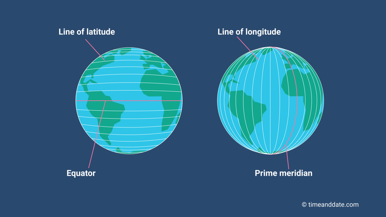
Longitudes are geographical positioning markers that run from the geographical North Pole to the geographical South Pole, intersecting the equator. They meet at both poles and specify the east-west position of a location. On a map where north is up, longitudes run vertically.
Longitudes are, therefore, imaginary circles that intersect the North and South Poles and the equator. Half of a longitudinal circle is known as a meridian. Meridians are perpendicular to every latitude.
Unlike, latitudes, there is no obvious central longitude. However, in order to measure the position of a location based on the longitude, cartographers and geographers over the course of history have designated different locations as the main longitudinal reference point. Today, the meridian line through Greenwich, England, is considered as the reference point for longitudes. This line is also known as the Prime Meridian.
The Prime Meridian is set as 0° longitude and it divides the Earth into the Eastern and the Western Hemispheres. All the other longitudes are measured and named after the angle they make with respect to the center of the Earth from the intersection of the meridian and the equator.
Since a sphere has 360 degrees, the Earth is divided into 360 longitudes. The meridian opposite the Prime Meridian (on the other side of the Earth) is the 180° longitude and is known as the antimeridian.
Modern timekeeping systems use longitudes as references to keep time. Time zones are defined by the Prime Meridian and the longitudes.
Fun fact: The meter was originally defined as one ten-millionth of the distance from the equator to the North Pole, along a meridian passing through Paris, France.
An Easy Way to Remember
One easy way to remember the orientation of latitudes and longitudes is longitudes are long, and latitudes are lateral.
Did You Know?
A Great Circle is any circle that is formed by a plane that passes through the center of the Earth. The equator and the circles created by the meridians form Great Circles.
The shortest line between two points on the Earth's surface is always the arc of a Great Circle. Because of this, Great Circles are important for the study of migration and other human interactions and activities, including shipping and airline routes.