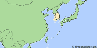
| Country: | South Korea |
|---|---|
| Lat/Long: | 37°34'N / 127°00'E |
| Currency: | South Korean Won (KRW) |
| Languages: | Korean |
| Country Code: | N/A |

°F
Weather
64 °F
More clouds than sun.
74 / 60 °F
| Tue 21. | 84 / 59 °F | |
| Wed 22. | 80 / 60 °F |
Weather by CustomWeather, © 2024
More Sun & Moon in 37°33'59.0"N, 126°59'58.9"E
+ Show More Twilight and Moon Phase Information
Solar Noon
Sun in South: 12:28 pm
Altitude: 72.5°
Altitude: 72.5°
Astronomical
Twilight
3:32 am – 4:12 am
8:45 pm – 9:25 pm
8:45 pm – 9:25 pm
Nautical
Twilight
4:12 am – 4:49 am
8:08 pm – 8:45 pm
8:08 pm – 8:45 pm
Civil
Twilight
4:49 am – 5:18 am
7:38 pm – 8:08 pm
7:38 pm – 8:08 pm
Previous
Moon Phase
First Quarter
May 15, 2024
8:48 pm
May 15, 2024
8:48 pm
Next
Moon Phase
Full Moon
May 23, 2024
10:53 pm
May 23, 2024
10:53 pm

Calendar & Holidays
Upcoming Holidays

Airports
- Gimpo International Airport, GMP
About 11 mi W of 37°33'59.0"N, 126°59'58.9"E - Incheon International Airport, ICN
About 31 mi WSW of 37°33'59.0"N, 126°59'58.9"E

37°33'59.0"N, 126°59'58.9"E
South Korea
8:1451am
Monday, May 20, 2024


