Is the Greenwich Meridian in the Wrong Place?
A GPS device does not show 0 degrees of longitude on the line marking the prime meridian at the Royal Greenwich Observatory in London, England. Why is that so?
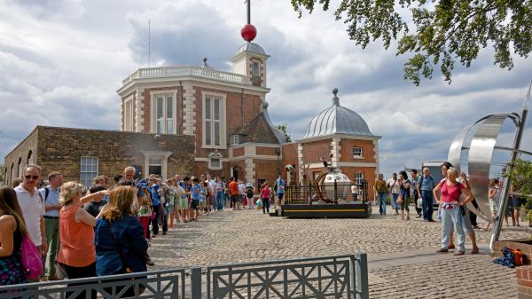
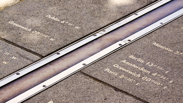
The line and monument marking the location of the original Greenwich Meridian in the Meridian Courtyard at the Royal Observatory in Greenwich, London, UK.
©Daniel Case
GPS Shows Different Meridian
Since everyone is running around with their own GPS tracker or mobile phones with GPS capability, a visit to the Royal Observatory in Greenwich, London may have become a slightly disappointing affair for some. The observatory is home to the Airy Transit Circle, a telescope designed by George Biddell Airy in the 19th century, which marks the location of the prime meridian, the line running along 0° of longitude, where the Earth's western and eastern hemispheres meet.
However, if you follow your GPS device to 0° longitude, you will end up a good distance away from the famous line marking the meridian in the observatory's Meridian Courtyard. So, have they been luring tourists to the wrong place for decades?
The Northern and Southern Hemispheres
Not Wrong, Just Different
Yes and no. It is true that the meridian that runs through the observatory has lost its status as the world's sole reference point for longitude. Navigation systems such as the GPS now use the IERS Reference Meridian (IRM), which runs about 334 feet (102 meters) east of the observatory.
However, although the world is now using an updated version, the location of the prime meridian is not wrong as such—it's just a different kind of meridian. It is defined by the location of the telescope, which was originally used to measure the passage of certain stars to feed data into an astronomical coordinate system, which, in its day, served as the basis for global navigation and timekeeping. Since the location of this original prime meridian is defined by the location of the telescope, it cannot be wrong: it is always where the telescope is.
Arbitrary Location
To understand how there can be two different prime meridians, both being in the correct location for their purposes, it's important to bear in mind that meridians and longitudes are a human invention, so there is essentially no right or wrong way to place them. While latitudes are defined by the Earth's shape and movement—the poles at 90° latitude are where the Earth's axis meets the Earth's surface and the equator at 0° latitude marks the middle point between the poles—there is no natural reason for any longitude to be used as the prime meridian.
At the International Meridian Conference in 1884, with multiple candidates to choose from, that honor was bestowed upon the longitude of the Airy Transit Circle in Greenwich. Apart from serving as a navigational reference point, the local mean time at the Greenwich Meridian now also served as the basis for the global time standard, Greenwich Mean Time (GMT), before being replaced by UTC in the 1960s.
UK doesn't follow GMT in the summer
Skewed Gravity
The problem with the Greenwich Meridian of 1884 was that it was based on measurements from a telescope situated in a particular location, which did not take into account the actual shape of our planet. The Earth is not a perfect sphere. It is slightly squashed at the poles and its mass is not distributed quite evenly. This means that measurements carried out at a particular location are not necessarily accurate for other locations.
In addition, a 2015 study suggests that the astronomers who calibrated the telescope even did so on slightly false premises. They used a pool of mercury to identify the exact direction of Earth's gravity and, therefore, the planet's center. In doing so, however, they did not take into account local distortions of gravity caused by the terrain, causing the telescope to be slightly off.
The line marking the original Prime Meridian at the Royal Observatory in Greenwich.
©iStockphoto.com/stocknshares
Satellites Move Prime Meridian
The need for an update to the location of the prime meridian became more and more palpable in the 1980s, as the world grew increasingly interconnected and global navigation and timekeeping became critically reliant on satellites. At the same time, new technologies provided much more accurate means of measuring the surface of the Earth.
Since satellites revolve around the Earth's center of gravity, scientists were now able to carry out their measurements from space, which allowed them to bypass the local irregularities mentioned earlier. As a result, they were able to generate a more precise spheroid, an idealized version of the basic shape of Earth, which was then used to calculate the updated position of the prime meridian.
This resulted in the implementation of the IRM, a prime meridian that is more accurately based on the actual center of Earth and better takes into account our planet's dips and bulges.
By the way, the IRM point is also used to calculate Universal Time, one of the main ingredients for Coordinated Universal Time (UTC), the world's time standard.
What is the difference between UTC and GMT?
Why Is the New Meridian Not Marked?
Many visitors to Greenwich are baffled when they find out that there is no sign, line, or monument marking the IRM, which runs through Greenwich Park. A number of GPS trackers famously pointed out that a dog litter bin is the most prominent landmark on the IRM.
While some are in favor of visualizing the IRM in Greenwich Park, others note that the meridian's location, in contrast to the original prime meridian, is not fixed. As tectonic plates move at a pace of a few centimeters per year, the IRM will take this slow shift into account, keeping the IRM in place in relation to the center of Earth. In effect, it will therefore slowly move over the Earth's surface, rendering any fixed markings obsolete after just a few years.
180° longitude: How does the International Date Line work?
Standards and Units Change All the Time
The prime meridian is not the only standard whose definition has changed over the years, as more precise means of measurement became available. For example, the second was once defined as 1/86,400 of a solar day, but now, it's the amount of time a caesium-133 atom in a precisely defined state oscillates 9,192,631,770 times.